Fires in the Earth System
Why fires are important
Fire plays a vital role in terrestrial ecosystems in the Earth system, regulating climate, vegetation and human activity. In fire-adapted landscapes such as boreal forests and savannas fire maintains the health of the ecosystem by clearing underbrush, releasing nutrients, and triggering seed germination. Fire is also a key part of the carbon cycle through emissions of greenhouse gases. But can also be detrimental to human populations through emissions of air pollutants, which are linked to negative health impacts when inhaled.
Changes in land-use, fire suppression and climate change all alter fire distribution spatially and temporally. Subsequently, the frequency and intensity of extreme fires is increasing globally.
Therefore, fires are central to both maintaining and destroying Earth ecosystems and rely on occurring in a frequency and intensity where they are beneficial to ecosystems and humans.
How we study fires
Studying fires and their impacts requires observations (from field and laboratory measurements) and modelling.
Observations
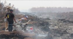
Field and laboratory measurements of key fire properties are essential in improving our understanding of fire behaviour and emissions. They are also key in being able to model the impacts of fires. For example, we must know how much of a specific air pollutant is emitted for a given mass burned by a fire (e.g. 1 g of CO per kg grassland burned). These measurements are made in the field or in the lab by sampling smoke plumes of fires (example below).
Satellite observations of fires are also key in identifying where and when fires occur globally. Detections are generally made once per day at 13:30 local time and provide key parameters such as fire size (burned area), intensity (fire radiative power) and persistence, if multiple days are combined. However, more recently geostationary satellites have enabled us to observe fires every 10 minutes. This allows us to learn much more about fire behaviour, including fire spread, plume behaviour and combustion type.
Emissions
Many of our TOMCAT group are involved in modelling the impacts of fires on air pollution. To model the impacts of fires, the key parameters needed are the location, timing, plume height and air pollutant emissions of each fire.
The location and timing of fires are retrieved directly from satellite observations of fires. However, the plume height and air pollutant emissions must be estimated combining other observational data with satellite observations.
Some of the key parameters we need to know to estimate emissions are:
- Burned Area: how much area was burned by a particular fire, which we can retrieve from satellite measurements.
- Combustion Completeness: how much of the vegetation present was burned (0-100 %).
- Emissions Factors: how much of a specific air pollutant is emitted for a given mass burned by a fire (e.g. 1 g of CO per kg grassland burned). These are from field and laboratory measurements for specific biomes.
These are combined to estimate emissions as shown below:
Emissions = BA × CC × EF
where BA = Burned Area, CC = Combustion Completeness, EF = Emissions Factor
There are many global and regional datasets estimating fire emissions using this method. These are used by our group as inputs to models which can then be used to understand the impact of fires on air quality.
Ailish Graham is working on a regional specific fire emissions for Indonesia dataset using similar approaches to this.
Evaluating Models
Our group extensively use ground-based and satellite observations of air pollution to evaluate modelling work we do. We use observations of air pollutants from government ground-based monitoring networks around the world. We also deploy our own networks of low-cost Purple Air PM2.5 sensors in regions where government monitoring is sparse, including Indonesia (shown below), which is impacted by severe peat fires in drought years.
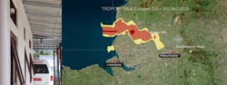
In addition to ground-based observations, we also use satellite observations of air pollution to evaluate models. An example from work by Richard Pope and Ailish Graham on the Saddleworth Moor fires in the UK is shown.
Future Projections of Fire
In addition to modelling the air quality impacts of present-day fires, several members of the group are involved in the evaluation of future projections of fire in the The Interactive Fires and Emissions algorithm for Natural Environments (INFERNO) within the UK Earth System Model (UKESM). This is vitally important in improving our understanding of how fire regimes may change in a changing world. INFERNO is an interactive fire model meaning it uses statistical relationships from observed fires to predict where fires will occur. It combines meteorological conditions (dry, hot weather with high fuel load) and likely ignitions (either lightning or human) to do this.
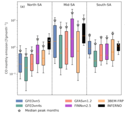
Work by Maria Veláquez-García carried out one of the first evaluations of INFERNO over South America (SA). Present-day modelled fire CO emissions from INFERNO (black) were evaluated over 3 regions of SA (North, Mid and South) using five satellite-based biomass-burning inventories, (GFEDvn5, GFEDvn4, GFASvn1.2, FINNvn2.5 and 3BEM-FRP) annually. This indicates that INFERNO is able to represent CO emissions in mid-SA. This is the most fire-active zone in SA, including the Amazon ’Arc of Deforestation’. However, the INFERNO overestimates emissions in both North- and South- SA. Understanding the drivers of the overestimates in North- and South- SA is key in INFERNO better representing present-day CO emissions. Therefore, improving model confidence for future scenarios.